PulseVi 3D Solid-State LiDAR Security System

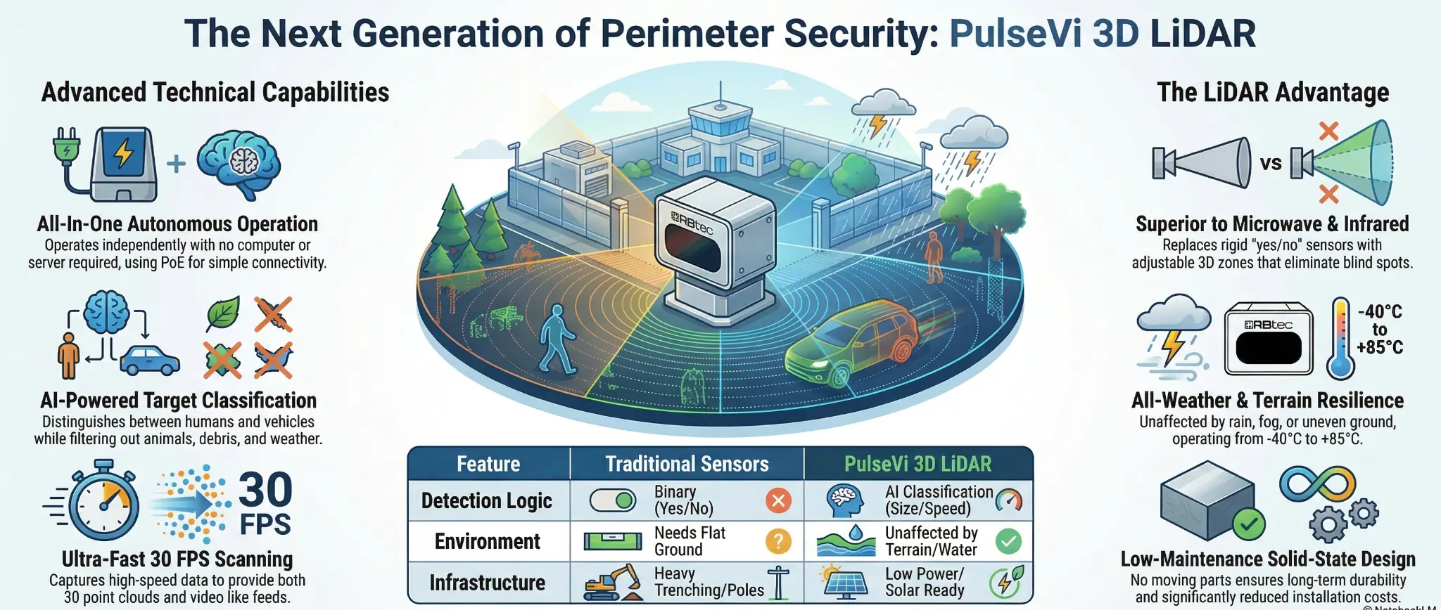
PulseVi 3D is an advanced solid-state LiDAR perimeter intrusion detection system that classifies humans and vehicles with AI, so alerts from animals, debris and weather are filtered out before they reach an operator.

Featuring high-speed 3D scanning at up to 30 FPS, AI-based target classification, detection ranges up to 300 m (1,000 ft), and simple infrastructure-free PoE deployment, it ensures reliable, full-coverage protection in any environment.
Trusted at substations, data centers, airports, and correctional facilities: high-security sites that demand accuracy, durability, and privacy-friendly perimeter protection. PulseVi is TAA and NDAA compliant for U.S. government and critical-infrastructure projects.

PulseVi Banner Web
PulseVi LiDAR perimeter detection coverage illustration

PulseVi System Layout Options

  • Parallel Virtual Fence (Outward-Looking Corridor)
    PulseVi is mounted parallel to the fence or wall, projecting a continuous detection corridor outward. Provides early detection and tracking of approaching targets before contact with the barrier.

  • Gate & Access Point Protection
    Dedicated coverage for vehicle gates, pedestrian gates, and controlled entries. Defines approach zones and threshold zones to monitor staging areas and movement directly toward entry points.

  • Roof & Elevated Approach Monitoring
    Sensors positioned to create a virtual perimeter along roof edges and typical ladder-access points. Detects vertical intrusion attempts and movement near hatches, skylights, and HVAC clusters.

  • Reinforcement of Weak Spots & Chokepoints
    Targeted layouts covering corners, low fence sections, culverts, berms, service roads, and other vulnerable segments. Uses focused approach zones to eliminate blind spots and prevent “hug-the-barrier” tactics.

How LiDAR Tells Humans and Vehicles Apart From Nuisance Alarms

PulseVi 3D LiDAR uses advanced intrusion detection with multiple layers of false alarm filtering:

  • Target Classification
    Distinguishes humans and vehicles by analyzing size, speed, and direction, while ignoring smaller objects like animals or debris.

  • Environmental Filtering
    Detects solid objects by measuring distance, so rain, wind and fog have far less effect than on camera-based analytics.

  • Customizable 3D Detection Zones
    Adjustable zones allow precise focus on relevant threats, ensuring complete coverage while filtering out non-threatening activity.

Innovative Solutions for Every Need

Purpose built perimeter detection for the industries where a breach costs the most.
Explore how RBtec fits yours:

Why Microwave & Infrared Sensors Are Not Enough

No Target Classification

Traditional microwave and infrared sensors provide simple yes/no alerts and cannot distinguish between humans, animals, or debris. LiDAR classifies targets by size, direction, and speed, significantly reducing false alarms.

High Installation Complexity & Cost

Microwave systems often require trenching, poles, and civil work. LiDAR operates on low power, supports solar options, and installs quickly without costly infrastructure.

Limited Environmental Flexibility

Microwave and infrared barriers rely on flat terrain and precise alignment. LiDAR performs reliably over uneven ground and standing water, allowing flexible mounting angles and heights.

Detection Gaps & Blind Spots

Line-of-sight limitations can leave coverage gaps with traditional sensors. LiDAR uses adjustable 3D detection zones to deliver complete, gap-free perimeter coverage.

PulseVi LiDAR sensor unit mounted for perimeter security

Protect Critical Sites with PulseVi 3D LiDAR

Ideal for a wide range of applications, PulseVi delivers precise, reliable perimeter protection:

  1. Critical Infrastructure: Power plants, water facilities, and utilities.

  2. Transportation: Airports, railways, and ports.

  3. Border Security: National and coastal borders.

  4. Industrial Facilities: Warehouses and manufacturing sites.

  5. Data Centers: Perimeter and interior protection for server rooms.

  6. Prisons & Military Bases: Perimeter security, virtual fences, and weapon storage.

  7. Smart Cities & Public Spaces: Parks, stadiums, and urban areas.

  8. Healthcare & Residential: Hospitals, pharmaceutical facilities, gated communities, and private estates.

  9. Event Security: Concerts, public gatherings, and temporary soft-spot protection.

RBtec’s Partners Worldwide
RBtec perimeter security system protecting a fenced facility
RBtec fence-mounted detection technology close-up
How Security 3D LiDAR Sensor Works
Models

RB-PulseVi23 · RB-PulseVi45 · RB-PulseVi80

Field of view (H × V)

PulseVi23: 22.5° × 6.5°
PulseVi45: 45° × 13°
PulseVi80: 80° × 22°

Detection range – typical

PulseVi23: 200 m (650 ft)
PulseVi45: 100 m (330 ft)
PulseVi80: 55 m (180 ft)

Detection range – maximum

PulseVi23: 300 m (1,000 ft)
PulseVi45: 150 m (500 ft)
PulseVi80: 70 m (230 ft)

Scan rate & output

Up to 30 Hz · 500,000 points/sec · 3D point cloud (x, y, z) with intensity & ambient data · video-like visualization

Laser

905 / 940 nm · Class 1, eye-safe

Power

PoE / PoE+ / PoE++ or 12 VDC (9–20 VDC) · 9.5 W typical, 10.5 W max

Connectivity & integration

1 Gigabit Ethernet · ONVIF · VMS integration incl. Milestone XProtect

Environmental

IP65 enclosure · −30 °C to +65 °C (−22 °F to 149 °F) operating temperature · no moving parts

Physical

109 × 68 × 100 mm · 750 g

Compliance

TAA and NDAA compliant, suitable for U.S. federal government and critical-infrastructure projects

A conventional camera records a two-dimensional image and uses image analytics to estimate object position and behavior. LiDAR directly measures the distance to points in the scene, producing three-dimensional coordinates. This allows zones to be defined in real-world 3D space and provides accurate target position data. Cameras remain useful for visual verification, so the technologies are often used together.

PulseVi is available in three field-of-view options. A narrower field of view provides greater range, while a wider field of view covers more area at a shorter distance.

ModelField of view (H x V)Typical range*Maximum observable range
RB-PulseVi2322.5° x 6.5°200 m (650 ft)300 m (1,000 ft)
RB-PulseVi4545° x 13°100 m (330 ft)150 m (500 ft)
RB-PulseVi8080° x 22°55 m (180 ft)70 m (230 ft)

*Typical range is based on the datasheet test condition of a 10 percent reflective Lambertian target at 90 klux. Practical detection and classification range depends on the target, mounting position, weather, obstructions, zone geometry and project acceptance criteria. RBtec models coverage from the site plan rather than treating maximum observable range as a guaranteed detection distance.


Yes. LiDAR is an active sensor and uses its own eye-safe laser pulses to measure the scene. It does not require visible lighting to produce a point cloud. Site conditions, obstructions and environmental attenuation can still affect performance and should be considered in the design.

The on-device analytics evaluate target dimensions, movement, speed and direction using the 3D point cloud. Alarms can be limited to configured target classes and behaviors, while objects that fall outside those rules can be ignored. Classification performance depends on having enough visible points on the target and on correct placement, zone design and commissioning.

Wind does not move the laser beam, but it can move vegetation or loose objects within the scene. Rain, snow, dust and fog can scatter or attenuate an optical signal, especially at longer distances or in severe conditions. PulseVi uses 3D filtering and classification to reduce environmental nuisance events, but no outdoor optical sensor is unaffected by every weather condition. Coverage should include the worst credible visibility conditions at the site and the required detection range.

No external analytics server is required for normal detection and classification. Processing runs on the sensor, which reduces the supporting hardware needed at the site. A VMS, alarm platform or Vidalert may still be used for centralized alarm handling, mapping, recording and camera workflows.

PulseVi uses a Gigabit Ethernet connection and consumes approximately 10 W, with typical consumption of 9.5 W and a listed maximum of 10.5 W. It can operate from a nominal 12 VDC supply with a 9 to 20 VDC working range, or through supported PoE equipment. The power method, cable distance, surge protection, grounding and any remote solar-power design should be confirmed in the project bill of materials.

The installer creates software-defined 3D zones within the field of view of the sensor. A zone can follow a fence line, cover a gate, define a corridor, protect a rooftop edge or monitor another restricted volume. Alarm rules can use target class, direction and movement behavior. Zones can be adjusted in software without physically relocating the sensor, provided the required area remains visible.

PulseVi can be mounted on a pole, wall, building or other stable structure in a horizontal or vertical orientation. The selected position must provide the required line of sight, target visibility and mounting rigidity. It can be useful on uneven terrain, above standing water or where a fence-mounted or buried sensor is impractical, but obstructions and terrain can still create hidden areas that require additional sensors or a different mounting point.

PulseVi can send alarms and target information into compatible IP-based security workflows. Depending on the selected integration, events can be displayed in a VMS or Vidalert, sent to an alarm platform, or used to trigger camera call-up and PTZ preset actions. Integration features vary by platform and version, so the required workflow should be confirmed during system design and tested during commissioning.

RBtec lists the current PulseVi product as TAA and NDAA compliant. The exact part number and country-of-origin documentation should be confirmed on the project quotation when compliance is a contractual requirement.

A LiDAR point cloud is a set of three-dimensional distance and intensity measurements, not a conventional color video image. It can classify and track movement without relying on facial detail. Privacy and data-retention requirements still depend on the integration, stored data and local policy, so they should be reviewed as part of the project.

Yes. PulseVi is solid-state, has no mechanical scanning assembly and is housed in an IP65-rated enclosure. It is designed for outdoor operation across extreme temperatures. The complete installation, including connectors, cabling, power equipment, mounting hardware and surge protection, must be selected for the environmental conditions at the site. Confirm the specified operating-temperature range for the exact orderable model in the current project datasheet.

Send RBtec a scaled site plan, photographs, required detection areas, target types, mounting restrictions, terrain details and the desired alarm or VMS integration. RBtec can model the field of view, identify likely mounting points, check for occlusions and prepare the recommended equipment list.

Still have questions?

Contact RBtec at +1 (301) 760-4016 with your site plan or photographs. Our team can review coverage, mounting and integration requirements and prepare a PulseVi concept design for your integrator.

Personal Information

Project Information

Protect Your Site with RBtec

RBtec delivers innovative perimeter security solutions trusted worldwide. With over 5,000 systems installed in 57 countries, our products combine reliability, cost-effectiveness, and user-friendly design for any site size or risk level.